NABUNKEN NEWS vol.45
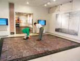
Introduction of a display of the Nara Palace Site Exhibition Hall – The photomap of the Nara Capital and surrounding areas (information room)
A large photomap (approx. one-seventeen hundredth scale) is displayed on the floor of the information room located immediately next to the entrance of the hall.
This photomap was created by superimposing the ground plot map (“Jobo”; ie, the city street layout organized on rectangular grids) of the ancient Nara Capital onto the aerial photograph of the present Nara Capital site (shot by the Geographical Investigation Institute in 2008). The entire photo image used for this display was generated by splicing more than 60 orthogonal images (ie, images transformed to be strain-free by adding accurate location-information to aerial photos), which was originally created for the floor display of a planning exhibition jointly held by the Geographical Investigation Institute and Nabunken in 2010.
This air view above the Nara Capital area will show you that the ancient ground plot and compartments still remain clearly in the present street layout. Please stand on the photomap, and take your time to study it.
(WATANABE Junko, Department of Planning and Coordination)
 |