NABUNKEN NEWS vol.45
Investigation on the Amakashi-no-oka Hill East Base Site (Asuka-Fujiwara 171st investigation)
Amakashi-no-oka hill is geographically complicated with a considerable number of intricate ravines. In this investigation too, the excavation site is located in one of the ravines spreading out toward the southeast. Through past investigations, extensive building structures, clay walls, etc. have been discovered, exhibiting aspects of ancient land use of the ground reclaimed on a large scale from the seventh to the early eighth century.
For this excavation, we delimited the investigation area of 880 square meters, located in the south of the 2009 investigation area, extending from an entrance to a ravine (in the southeast of the ravine) to the foot of a hill (in the northeast of the ravine). The period of investigation was from September 22, 2011 to April 26, 2012.
The foot of the hill comprising the northern half of the entire investigation area has been largely scraped away by agriculture in subsequent ages. The southern investigation area corresponds to the northern slope of a ravine spreading out toward the southeast and sloping down toward the south. This slope was artificially scraped down and created as a vertical two-stage tier. On the upper tier, a number of structural remains including a hard surface and stone pavement continued from those previously discovered through the 2009 investigation, square structural remain, reddened surface and a building featuring dug-standing pillars covering those remains were found. Meanwhile, on the lower tier, a building featuring dug-standing pillars and other relics were discovered. On the upper tier, soil containing a large amount of charcoal fragments and burnt wall mud was piled up to about 20 centimeters, and thereon, the soil that was used to reclaim the entire ravine including the upper and lower tiers was piled up to about 1.5 meters thick. Since the earthenware of the middle seventh century was unearthed from these soil layers, the structural remains of the upper and lower tiers was conceivably built during the period from the early to the middle seventh century.
The hard surface found on the upper tier is tinged with gray and dark umber, possibly proving that it was hardened by intense heat. This structural remain is divided into roughly three sections. Of the three, two sections, the shape of which have, to a certain extent, been determined, retain an elongated hard surface with the main axis running between north-north-east and south-south-west, covering about 1.6 - 2.0 meters in width and 5 meters in length. The Northern section gently slopes and is slightly higher, suggesting the likelihood that it is a part of the floor or underground structure of a kiln.
Three square structural remains were found on the east side of the hard surface, each of which forms an irregular square with a single side of approx. 0.8 meters. The surface of reddened or burnt wall mud is piled up in places. Beneath the surface, ditches and pits exist as annexed structures, but their intended use is still undetermined.
The reddened surface is possibly yellow clay soil prepared for leveling and continuously exposed to intense heat in the following periods. It was discovered to the east of the hard surface and in the southeast of the square structural remain, extending to about 2.5 meters in the east-west direction and about one meter in the north-south direction. Overlapping this remain, a building featuring dug-standing pillars measuring 1 × 1 span and spanning 2.4 meters in the east-west direction and 2.1 meters in the north-south direction was also discovered. This building was probably composed of the furnace and the covering roof.
In addition, in the southwest section of the investigation area, a stone paved ditch of 1.2 - 1.5 meters wide runs from the northwest to the southeast.
Furthermore, a building featuring dug-standing pillars measuring two spans in the north-south direction and two spans in the east-west direction, with the major axis from north-north-west to the south-south-east was found on the lower tier. The span distance is about 1.8 meters in the east-west direction, and about 2.4 meters in the east-west direction. The ground around the building was leveled by alternately laying thin, fine charcoal layers and clayey soil layers.
Meanwhile, on the southwest corner of the investigation area, a charcoal heap, likely to be an exposed part of the fine charcoal layer used for leveling soil for the building, was unearthed, in addition to the charcoal piled up in the ravine.
The hard surface, reddened surface, and the square structural remain discovered through this excavation may possibly be production-related facilities using fire, such as a kiln, furnace, etc. At least, this discovery suggests that the site was part of an ancient workshop-like place. Although it has been known for quite a long time that this ravine had buildings and mud walls here and there in the early to middle seventh century, this excavation has found that the entrance area of the ravine exhibits the different aspects of land use.
However, from the structural remain and relics unearthed during this excavation, we could not ascertain their specific intended use, including what was produced here. We are currently examining soil samples and fine relics minutely as well as completing sorting/arrangement work.
(SEINO Takayuki, Department of Imperial Palace Sites Investigations)
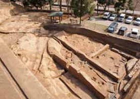 Full view of the entire investigation area seen from the west. The lower right side is the entrance of the ravine. |
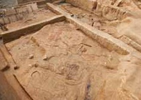 A square structural remain is in this side; reddened and hard surfaces are at the rear (Seen from the east) |